ATLANTA BELTLINE
ATLANTA, GEORGIA
United States
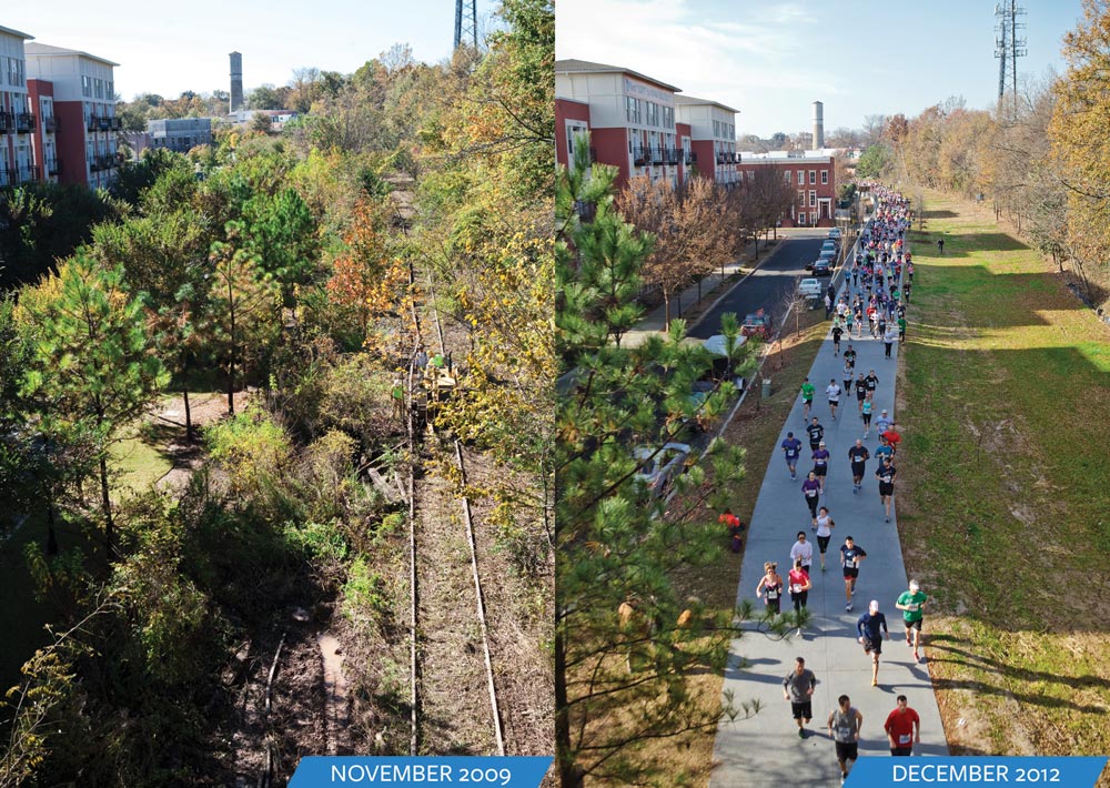
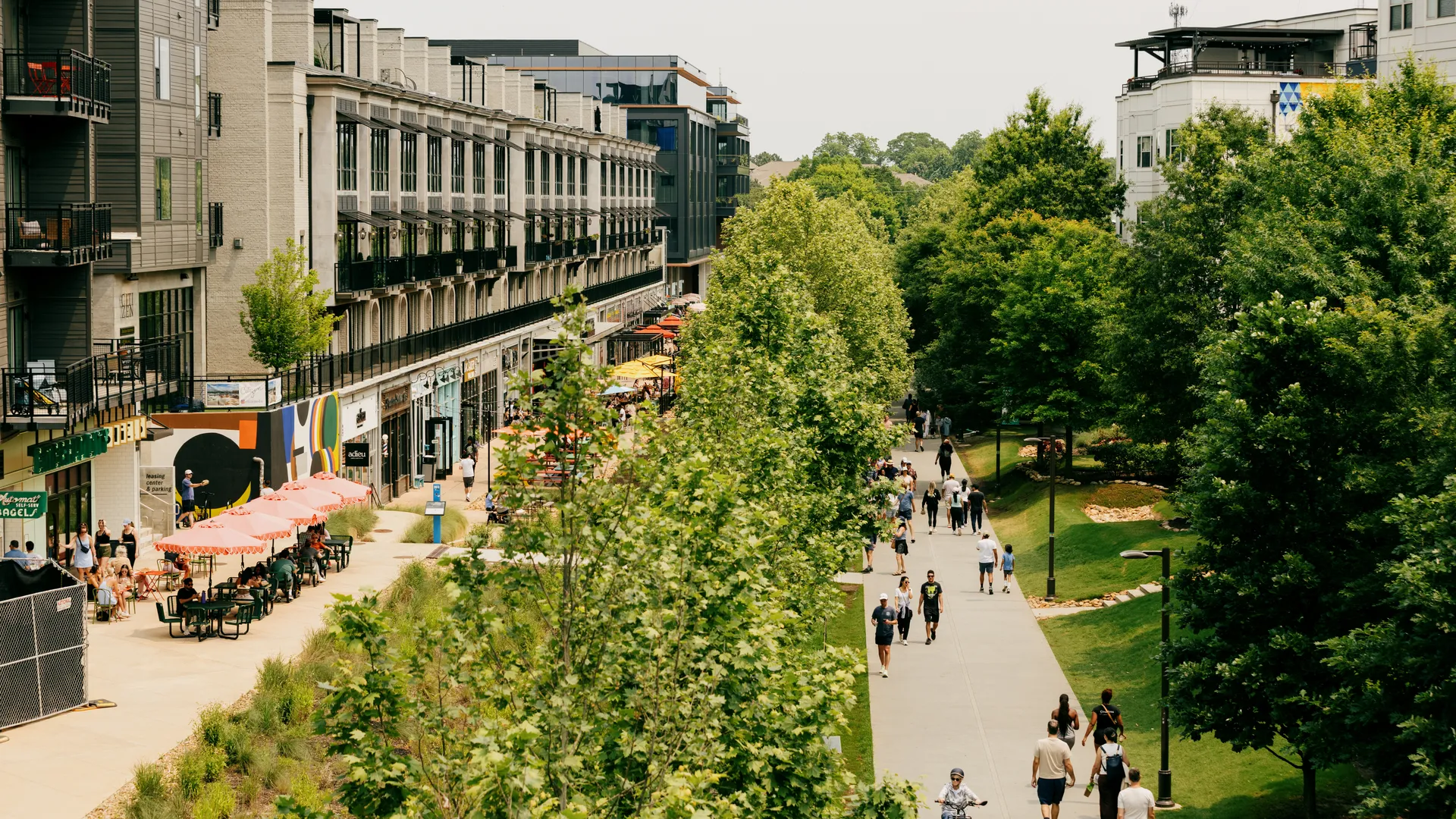
The Atlanta BeltLine is one of the largest, most comprehensive urban redevelopment and mobility projects currently underway in the United States. It is a sustainable urban regeneration initiative that transforms a 22-mile historic railroad corridor into a continuous network of multi-use trails, modern streetcar transit, and parks. The project’s “nodes” are key intersection points where this infrastructure catalyses dense, mixed-use development, affordable housing, and community-focused amenities.
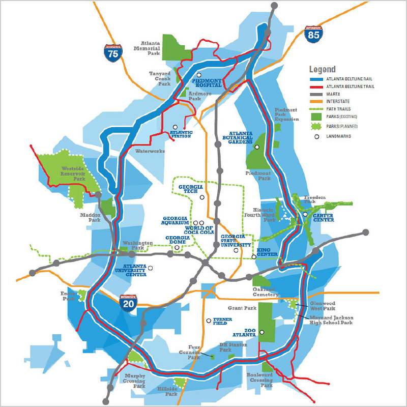
The BeltLine forms a roughly circular corridor linking Midtown, Old Fourth Ward, Inman Park, Reynoldstown, West End, English Avenue, Bankhead, Grove Park and many other neighbourhoods. The Atlanta Beltline Redevelopment Plan (2005) and subarea masterplans define a transit-oriented corridor with mixed-use “nodes” around key trail intersections and future stations. The nodes such as Ponce City Market, West End, Murphy Crossing, and Grove Park focus on compact, walkable development that blends housing, commerce, and civic spaces.
Future Cities criteria compliance
Environmental & Nature
The project transforms 22 miles of disused railway into 33 miles of multi-use trails and over 1,300 acres of new greenspace. It involves extensive environmental remediation, cleaning up over 1,100 acres of contaminated brownfield sites. Large-scale reforestation and planting combat the urban heat island effect and improve air quality and stormwater management. By providing pedestrian and transit alternatives, the BeltLine reduces private car dependence and addresses regional sprawl and congestion.
Smart City
The corridor is officially zoned for future Light Rail Transit (LRT) or streetcar lines, linking into the MARTA regional system. Planning relies on GIS technology and subarea master plans for transparent land use and zoning management. Construction includes utility duct banks beneath trails for future power, lighting, and transit infrastructure. Development nodes like Murphy Crossing are being coordinated with new MARTA infill stations for maximum transit accessibility and connectivity.
Human-Centric
The project connects 45 neighbourhoods previously separated by infrastructure, fostering community and cultural engagement. The Equitable Development Plan commits to creating and preserving 5,600 units of affordable housing adjacent to the corridor. It aims to create over 50,000 permanent and construction jobs, prioritizing local hiring from nearby neighbourhoods. The continuous loop provides safe, accessible trails promoting a healthier lifestyle for walking, biking, and recreation for all residents.
Interesting Links
Links to external websites and video features available for cities and developments that apply and are accepted as Official Participants: click here to apply